
Image: Slovakia borderHungary
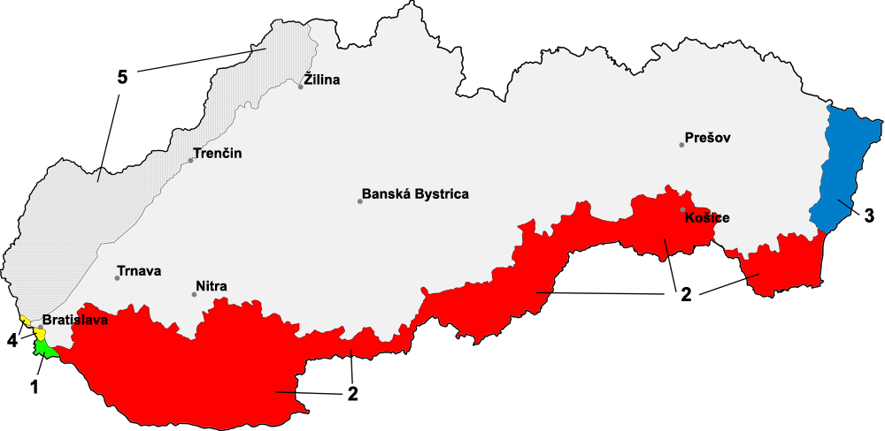
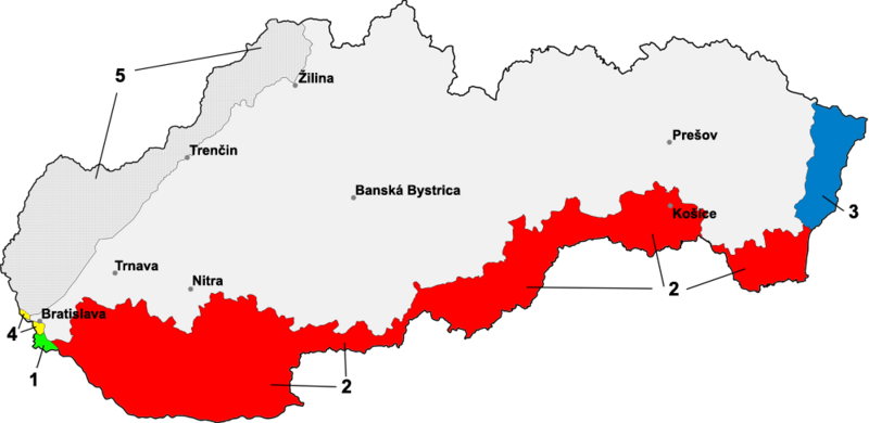
Description: Map of Slovakia with border-changes in the south and east against Hungary & Germany (1939-1945) 1 — Bratislava bridgehead, part of Hungary until 15 October 1947 2 — Southern Slovakia, from 2 November 1938 until 1945 to Hungary, due to the First Vienna Award 3 — Strip of land in eastern Slovakia around the cities of Stakčín & Sobrance, part of Hungary from 4 April 1939 (following the Slovak–Hungarian War) until 1945 4 — Devín and Petržalka (now parts of the city of Bratislava), from 1938 until 1945 part of Germany 5 — German “Protection Zone”, military occupation as a result of the protection treaty with Slovakia Note: Transfers on the Slovak-Polish border not marked
Title: Slovakia borderHungary
Credit: "Na pripojenie Jaroviec, Rusoviec a Čunova sa zabúda". SME.sk. Retrieved on 2 February 2020. This source should cover #2 (upn is the National Memory Institute) Kirschbaum, Stanislav J. (2016) A History of Slovakia: The Struggle for Survival, St. Martin's Publishing Group, p. 190 ISBN: 978-1-250-11475-4. Lemkin, Raphael (2005) Axis Rule in Occupied Europe: Laws of Occupation, Analysis of Government, Proposals for Redress, The Lawbook Exchange, Ltd., p. 130 ISBN: 978-1-58477-576-8. Rychlík, Jan (2017) "Slovakia (section: The Slovak Republic, 4th paragraph)" in (in English) Joining Hitler's Crusade European Nations and the Invasion of the Soviet Union, 1941, Cambridge UP
Author: Martin Proehl / Murli
Usage Terms: Creative Commons Attribution-Share Alike 3.0
License: CC BY-SA 3.0
License Link: http://creativecommons.org/licenses/by-sa/3.0/
Attribution Required?: Yes
Image usage
The following page links to this image:
