
Image: Shubenacadierivermap

Size of this preview: 726 × 600 pixels. Other resolutions: 291 × 240 pixels | 806 × 666 pixels.
Original image (806 × 666 pixels, file size: 68 KB, MIME type: image/png)
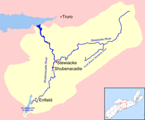
Description: This is a map of the Shubenacadie River drainage basin. I created it using data from the Topographical Atlas of Canada[1].
Title: Shubenacadierivermap
Credit: I created this work entirely by myself.
Author: Andrew647
Usage Terms: Creative Commons Attribution-ShareAlike 3.0
License: CC-BY-SA-3.0
License Link: https://creativecommons.org/licenses/by-sa/3.0/
Attribution Required?: Yes
Image usage
The following 2 pages link to this image:

All content from Kiddle encyclopedia articles (including the article images and facts) can be freely used under Attribution-ShareAlike license, unless stated otherwise.