
Image: SanJacinto Watershed

Size of this preview: 659 × 600 pixels. Other resolutions: 264 × 240 pixels | 811 × 738 pixels.
Original image (811 × 738 pixels, file size: 103 KB, MIME type: image/png)
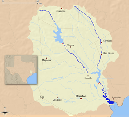
Description: Map of the San Jacinto River watershed in southeast Texas — with its mouth at Galveston Bay. Credits I, Kuru, created from data originating at the USGS.
Title: SanJacinto Watershed
Credit: No machine-readable source provided. Own work assumed (based on copyright claims).
Author: No machine-readable author provided. Kuru assumed (based on copyright claims).
Usage Terms: Creative Commons Attribution-Share Alike 2.5
License: CC BY-SA 2.5
License Link: http://creativecommons.org/licenses/by-sa/2.5
Attribution Required?: Yes
Image usage
The following 4 pages link to this image:

All content from Kiddle encyclopedia articles (including the article images and facts) can be freely used under Attribution-ShareAlike license, unless stated otherwise.