
Image: Salyens villes map-fr

Size of this PNG preview of this SVG file: 479 × 340 pixels. Other resolution: 320 × 227 pixels.
Original image (SVG file, nominally 479 × 340 pixels, file size: 1.49 MB)
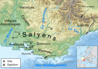
Description: Map of the Salyens and Provence tribes in early Roman times.
Title: Salyens villes map-fr
Credit: travail personnel from File:France map Lambert-93 topographic-blank.svg by User:Sting, verified by [1]
Author: Bourrichon - fr:Bourrichon
Permission: You may select the license of your choice.
Usage Terms: Creative Commons Attribution-Share Alike 3.0
License: CC BY-SA 3.0
License Link: https://creativecommons.org/licenses/by-sa/3.0
Attribution Required?: Yes
Image usage
The following page links to this image:

All content from Kiddle encyclopedia articles (including the article images and facts) can be freely used under Attribution-ShareAlike license, unless stated otherwise.