
Image: Rockall EEZ topographic map-en

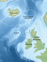
Description: Map of exclusive economic zones of the UK, Republic of Ireland, the Faroe Islands (Denmark) and Iceland around Rockall, United Kingdom. Cartographic data : Lambert conformal conic projection First standard parallel : 50 Second standard parallel : 65 Central meridian : -13.7 Origin latitude : 57.5 Limits of the map : N 69, W -24, S 47, E 01 Modified from original map by Sémhur, to include 2014 EEZ changes for UK and Ireland and to label points mentioned in Rockall article
Title: Rockall EEZ topographic map-en
Credit: Own work Source : Topography & Bathymetry : SRTM30 Plus Shorelines : NGDC GSHHS Exclusive Economic Zones: Maritime Boundaries Geodatabase: Maritime Boundaries and Exclusive Economic Zones (200NM), version 10
Author: Liam Mason
Usage Terms: Creative Commons Attribution-Share Alike 4.0
License: CC BY-SA 4.0
License Link: https://creativecommons.org/licenses/by-sa/4.0
Attribution Required?: Yes
Image usage
