
Image: River-Poddle-2010-02-19b

Size of this preview: 800 × 600 pixels. Other resolutions: 320 × 240 pixels | 1,000 × 750 pixels.
Original image (1,000 × 750 pixels, file size: 232 KB, MIME type: image/jpeg)
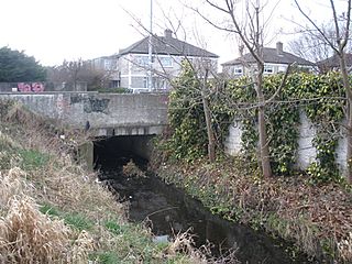
Description: View of the River Poddle, Dublin, where it forms the border between the townlands of Templeogue (left bank, or south) and Whitehall (right bank, or north) at this location. The river is emerging from underneath Templeville Road, flowing northeast towards the camera. See also River-Poddle-2010-02-19a.jpg and River-Poddle-2010-02-19c.jpg.
Title: River-Poddle-2010-02-19b
Credit: Own work
Author: User:O'Dea
Usage Terms: Creative Commons Attribution-Share Alike 4.0
License: CC BY-SA 4.0
License Link: https://creativecommons.org/licenses/by-sa/4.0
Attribution Required?: Yes
Image usage
The following page links to this image:

All content from Kiddle encyclopedia articles (including the article images and facts) can be freely used under Attribution-ShareAlike license, unless stated otherwise.