
Image: Rhodes NLT Landsat7

Size of this preview: 605 × 600 pixels. Other resolutions: 242 × 240 pixels | 1,948 × 1,931 pixels.
Original image (1,948 × 1,931 pixels, file size: 2.21 MB, MIME type: image/png)
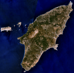
Description: Visible colour satellite image of Rhodes.
Title: Rhodes NLT Landsat7
Credit: Screenshot from NASA World Wind, NLT Landsat7 layer. Coordinates: worldwind://goto/world=Earth&lat=36.16654&lon=27.93315&alt=80698
Author: Photograph: NASA
Permission: Public domainPublic domainfalsefalse This image is in the public domain because it is a screenshot from NASA’s globe software World Wind using a public domain layer, such as Blue Marble, MODIS, Landsat, SRTM, USGS or GLOBE. العربيَّة | English | فارسی | français | עברית | македонски | മലയാളം | Nederlands | русский | 中文(中国大陆) | +/−
Usage Terms: Public domain
License: Public domain
Attribution Required?: No
Image usage
The following 2 pages link to this image:

All content from Kiddle encyclopedia articles (including the article images and facts) can be freely used under Attribution-ShareAlike license, unless stated otherwise.