
Image: Relief Map of Baltic Sea

Size of this preview: 501 × 599 pixels. Other resolutions: 201 × 240 pixels | 869 × 1,039 pixels.
Original image (869 × 1,039 pixels, file size: 1.14 MB, MIME type: image/png)
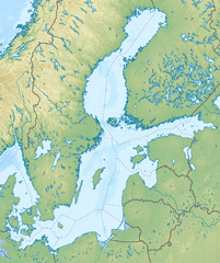
Description: Relief map of the Baltic Sea with national borders added
Title: Relief Map of Baltic Sea
Credit: ETOPO1 for relief and bathymetry File:Baltic Sea location map.svg for country borders; by NordNordWest, CC-BY-SA-3.0-DE Own work using This map was created with GMT. This PNG graphic was created with Inkscape .
Author: Nzeemin, NordNordWest
Usage Terms: Creative Commons Attribution-Share Alike 3.0
License: CC BY-SA 3.0
License Link: https://creativecommons.org/licenses/by-sa/3.0
Attribution Required?: Yes
Image usage

All content from Kiddle encyclopedia articles (including the article images and facts) can be freely used under Attribution-ShareAlike license, unless stated otherwise.