
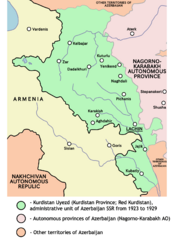
Image: Red kurdistan 1923 1929

Size of this preview: 435 × 599 pixels. Other resolutions: 174 × 240 pixels | 1,205 × 1,659 pixels.
Original image (1,205 × 1,659 pixels, file size: 123 KB, MIME type: image/png)
Description: Map of Kurdistan uezd (Red Kurdistan) from 1923 to 1929 (borders according to the Kurdish historian Mehrdad Izady).
Title: Red kurdistan 1923 1929
Credit: Own work
Author: PANONIAN
Usage Terms: Creative Commons Zero, Public Domain Dedication
License: CC0
License Link: http://creativecommons.org/publicdomain/zero/1.0/deed.en
Attribution Required?: No
Image usage
The following page links to this image:

All content from Kiddle encyclopedia articles (including the article images and facts) can be freely used under Attribution-ShareAlike license, unless stated otherwise.