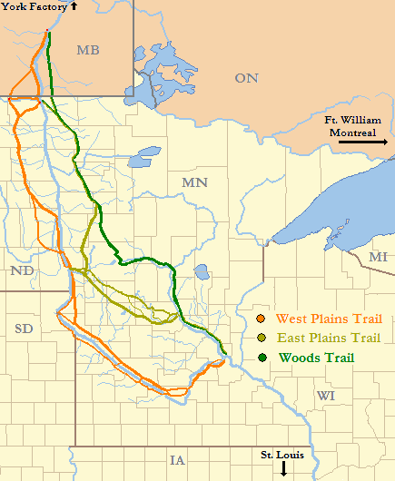
Image: Red River Trails Locator Map cropped
Description: Locator Map of Red River Trails, Canada and United States; cropped from this version to remove title, and slightly edited.
Title: Red River Trails Locator Map cropped
Credit: Base maps of North Dakota, South Dakota, Minnesota, Iowa, Wisconsin, and Michigan taken from US Census website [1] and modified by User:Ruhrfisch; separate state maps combined and further modified by User:Kablammo to show routes of principal trails, watercourses intersecting those trails, and certain major water trade routes (no attempt is made to show other rivers), using maps and information from: Gilman, Rhoda R., Gilman, Carolyn, & Stultz, Deborah M. Stultz, (1979). The Red River Trails: Oxcart Routes Between St. Paul and the Selkirk Settlement, 1820-1870. St. Paul: Minnesota Historical Society Press. ISBN 0-8735-1133-6 Kelsey, Vera (1951). Red River Runs North! New York: Harper & Brothers Lass, William E. (1980). Minnesota’s Boundary with Canada. St. Paul: Minnesota Historical Society Press. ISBN 0-8735-1153-0 Morse, Eric W. (1969). Fur Trade Canoe Routes of Canada / Then and Now. Minocqua, WI: NorthWord Press. ISBN 1-5597-1045-4
Author: US Census, Ruhrfisch, Kablammo
Permission: US Census / US Government work in public domain, modifications by Ruhrfisch licensed under the GNU Free Documentation License; further modifications by Kablammo under same GNU Free Documentation License.
Usage Terms: Public domain
License: Public domain
Attribution Required?: No
Image usage
The following 2 pages link to this image:


