
Image: Ramusio & Gastaldi Universale della Parti della Mondo 1556 UTA
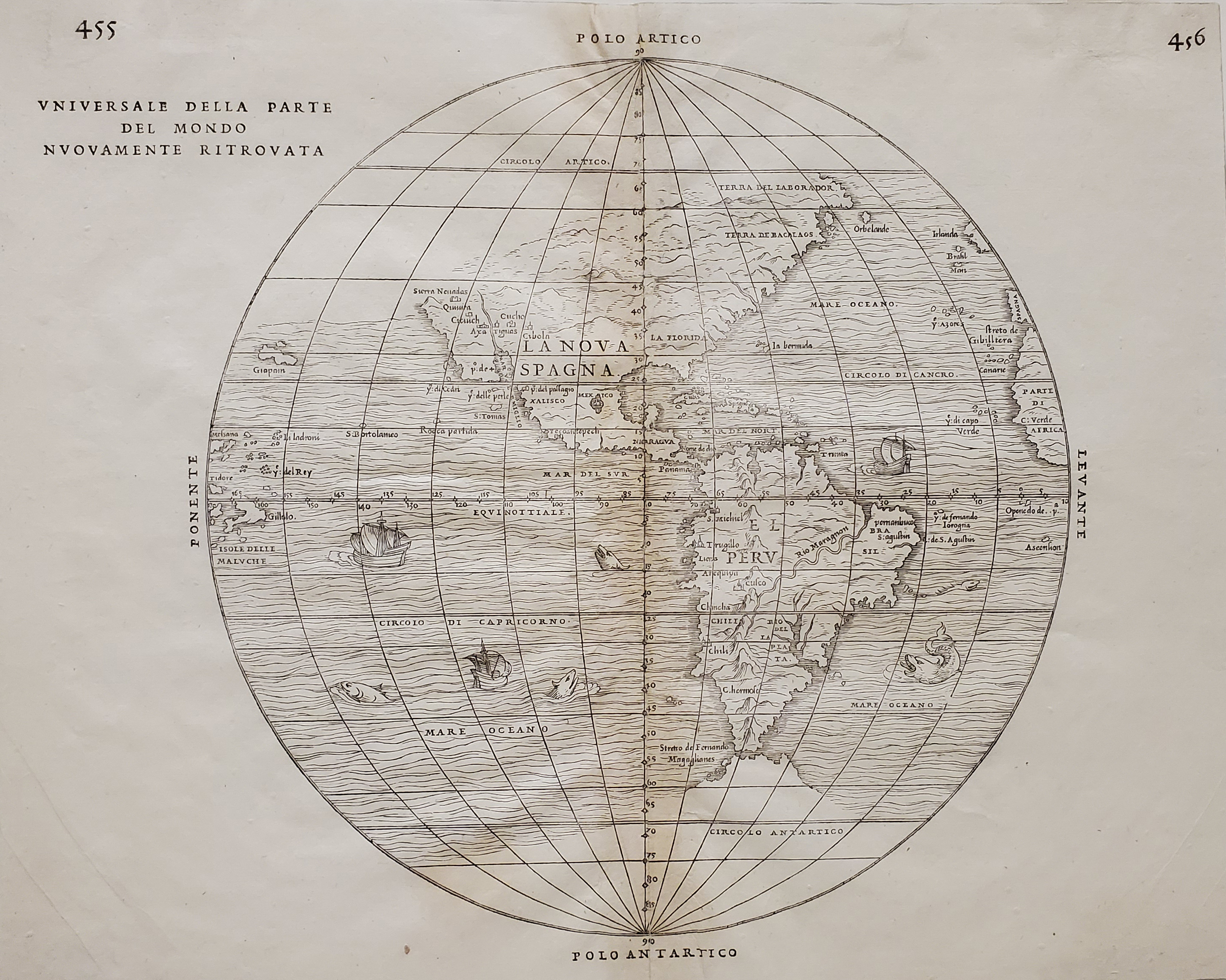
Description: This Italian hemispherical view of the New World was the first printed map to include place names from Francisco Vásquez de Coronado's expedition of 1540-1542, the first major Spanish exploration or Entrada into what became New Spain's northwestern territories. The map lists the names of some of the rumored seven cities of gold that were actually the pueblos of present Arizona and New Mexico. Coronado's "Cibola" appears to be Hawikuh, a Zuni ruin in what is today far western New Mexico. On this map "Quivira" appears to its northwest, rather than to the northeast, in present Kansas, where Coronado’s account located it. Also mentioned is "Tiguas"–the site of the Tiguex War of 1540-1541 between Coronado's men and the Puebloan Tiwas. Although Coronado source descriptions placed these people on both sides of the Rio Grande in present New Mexico, the map places them in what is now far western Arizona along a river like the mighty Colorado ascending north from the "Mer del Vermiglio" or Gulf of California. A pattern develops, suggesting that the mapmakers positioned all of the remaining pueblos "Cucho", "Axa", and "Cicuich" in the opposite direction (west) from what most scholars would have the Coronado narratives suggest. The "Sierra Nevadas" appear along the California coast in reference to Juan Rodriguez de Cabrillo's voyage of 1542 (the first recorded European exploration of the coastline of the present state of California). Venetian historian, geographer, translator, and editor Giovanni Battista Ramusio (1485-1557)commissioned the Italian astronomer, cartographer, and engineer Giacomo Gastaldi (ca.1500-1566) to produce the map for a collection of travels that included an account of Coronado's expedition, Fray Marcos de Niza's report (describing one of the Seven Cities of Cibola), as well as information on Columbus, Balboa, Cabeza de Vaca, Cortés, Cabrillo, and others.
Title: General Map of the Newly Discovered Part of the World
Credit: UTA Libraries Cartographic Connections: map / text
Author: Giovanni Battista Ramusio / Giacomo Gastaldi
Usage Terms: Public domain
License: Public domain
Attribution Required?: No
Image usage
The following page links to this image:
