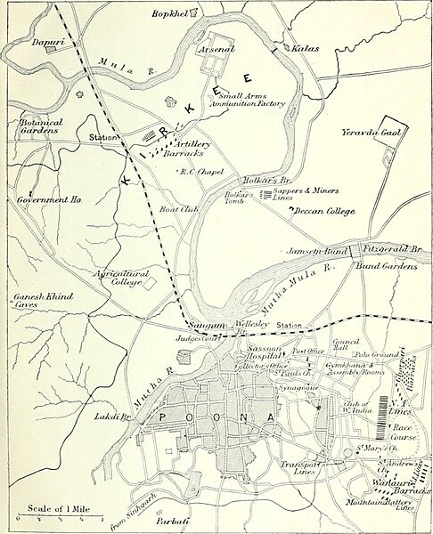
Image: Pune Poona 1911 map

Description: Identifier: handbooktravelle00john Title: A handbook for travellers in India, Burma, and Ceylon . Year: 1911 (1910s) Authors: John Murray (Firm) Subjects: India -- Guidebooks Burma -- Guidebooks Sri Lanka -- Guidebooks Publisher: London : J. Murray Calcutta : Thacker, Spink, & Co. Contributing Library: University of California Libraries Digitizing Sponsor: MSN View Book Page: Book Viewer About This Book: Catalog Entry View All Images: All Images From Book Click here to view book online to see this illustration in context in a browseable online version of this book. Text Appearing Before Image: e Band, the FitzgeraldBri.ige, and the Band Gardens,for all of which see below underPoona. Government House is at GaneshKhind, i^ m. S.W. of Kirkee Rail-way Station, and 3^ m. N.W. of thecity of Poona. It derives its namefrom a small khind or pass betweenhills, about f m. S. E. of the house,which resembles a modern Frenchchateau, and has a tall slim tower,80 ft. high, from the top of whichthere is a fine view including Kirkee,with its Arsenal, the Deccan College,and the Parbati Hill. The housecontains the usual reception rooms, aball-room, darbar-room, etc., andhas a flower gallery or garden corridor,90 ft. long. 119 m. POONA ^ junction of theG.I.P. and Madras and S. MahrattaRailways. The railway station issituated at a corner of the city andcantonment, and close to the publicoffices. Poona (Lat. 18° 31, Long.73 51; altitude 1850; population,157,000) is the residence of theGovt, of Bombay during the rains.It is the headquarters of the 6thArmy Division, and the former POONA AND KIRKEE Text Appearing After Image: Scale of 1 Wile0 ■« s \ 1 Parbaiv L [To face p. 342. ROUTE 25. POONA 343 capital of the Mahrattas. The firstmention of Poona is in the Mahrattaannals of 1599 a.d., when the par-ganahs of Poona and Supa weremade over to Malaji Bhonsle (grand-father of Shivaji) by the Nizam ShahiGovernment. In 1750 it became theMahratta capital under Balaji BajiRao. In 1763 it was plundered anddestroyed by Nizam All, and here,on the 25th of October, Jaswant RaoHolkar defeated the combined armiesof the Peshwa and Sindhia, andcaptured all the guns, baggage, andstores of the latter. The city standsin a somewhat treeless plain on theright of the Mutha river, a little beforeit joins the Mula. At its extreme S.limit is the hill of Parbati, so calledfrom a celebrated temple of thegoddess Durga, or Parvati, on itssummit (see p. 345). A few m. tothe E. and S.E. are the hills whichlead up to the still higher tablelandin the direction of Satara. Thestation is healthy and the climatepleasant. The Aqueduct was bu Note About Images Please note that these images are extracted from scanned page images that may have been digitally enhanced for readability - coloration and appearance of these illustrations may not perfectly resemble the original work.
Title: Pune Poona 1911 map
Credit: Image from page 537 of "A handbook for travellers in India, Burma, and Ceylon ." (1911)
Author: Internet Archive Book Images
Permission: Internet Archive Book Images @ Flickr Commons
Usage Terms: No known copyright restrictions
License: No restrictions
License Link: https://www.flickr.com/commons/usage/
Attribution Required?: No
Image usage
The following page links to this image:

