Image: PryorPioneerBackCountry

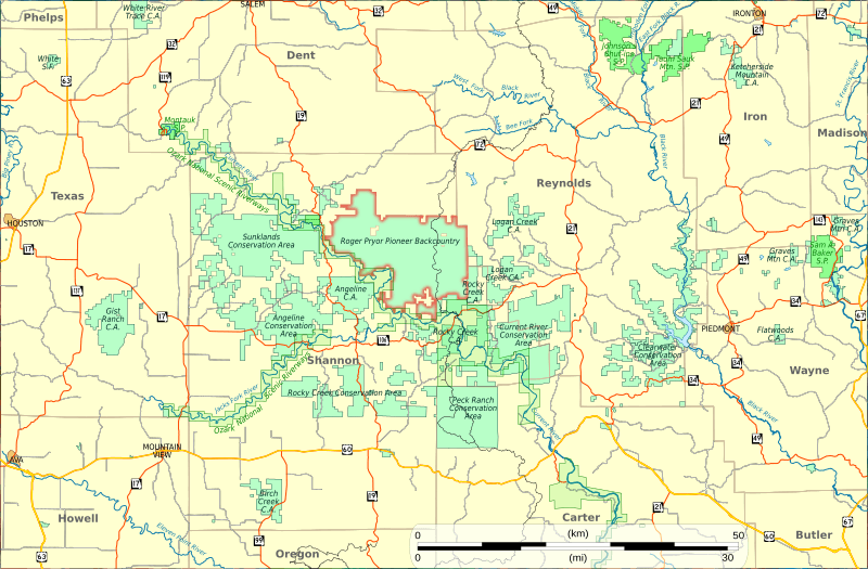
Description: Location map of Roger Pryor Pioneer Backcountry in the Ozarks of the state of Missouri. It consists of 95 sq mi (246 km2) of privately held forest land belonging to Leo Drey's L-A-D Foundation. There are many public lands in the surrounding area: conservation areas, a national park, state parks, and national forests. Boundaries for the Backcountry area were derived from a map published on the Pioneer Forest website.[1]. Boundaries for the Ozark National Scenic Rivers national park and urban areas are from the National Atlas of the United States.[2] Boundaries for roads, state parks, state conservation areas, and Missouri counties are from Missouri Spacial Data Information Service.[3] The route of the Ozark Trail is from a shapefile provided by the Ozark Trail Association (2009). Some boundaries for conservation areas, the Ozark National Scenic Riverways, and the Pryor Backcountry overlap on this map. It is unknown to the creator of this map whether that is from inaccurate/inconsistent data from multiple sources, or whether in some cases there is overlap -- the state does administer conservation areas on land leased from other owners in some cases, e.g. The map is projected in the UTM Zone 15 North coordinate system. The upper-left and lower-right corners of the map are at 91°58'43"W, 37°38'21"N and 90°27'56"W, 36°48'54"N; the center of the map is at 91°13'5"W, 37°13'46"N. In UTM15N coordinates, those corners are at 590090 east, 4166281 north and 726064 east, 4077374 north, with the center at 658077 east 4121828 north.
Title: PryorPioneerBackCountry
Credit: Own work
Author: Kbh3rd
Usage Terms: Creative Commons Attribution-Share Alike 3.0
License: CC BY-SA 3.0
License Link: https://creativecommons.org/licenses/by-sa/3.0
Attribution Required?: Yes
Image usage
The following page links to this image:

