
Image: Polish-Lithuanian Commonwealth at its maximum extent

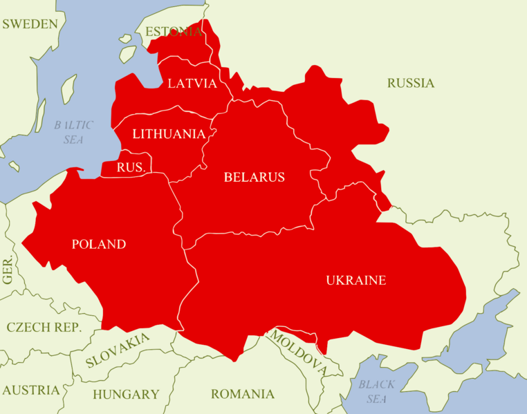
Description: A map showing the Polish–Lithuanian Commonwealth at its maximum extent following the Truce of Деулино, superimposed on present-day national borders. The map shows in red all of the territory that was ruled by Zygmunt III Waza in 1619 (the Polish monarch at that time), which made up the Commonwealth; it can be further divided up into: Crown of the Kingdom of Poland Duchy of Prussia (Polish fief) Grand Duchy of Lithuania Duchy of Courland and Semigallia (Lithuanian fief) Duchy of Livonia (joint dominion) In the early 17th century, the Polish-Lithuanian Commonwealth was one of the largest and most populous countries in Europe, comprising about 1,000,000 km2 (390,000 sq mi) of land with a population of some 12 000 000 people (5m Ruthenians, 4.5m Poles, 0.75m Lithuanians, 0.75m Prussians, 0.5m Jews and 0.5m Livionians). As can be seen on the map, the Commonwealth's territory was - in terms of present-day borders - equal to: most of Poland and Ukraine; all of Belarus, Lithuania, Latvia and the Kaliningrad Oblast; much of Estonia; parts of Russia (including Smoleńsk); as well as small parts of Moldova and Romania.
Title: Polish-Lithuanian Commonwealth at its maximum extent
Credit: Created by me using graphics editing software, then converted to SVG format. It is based on this design: https://commons.wikimedia.org/wiki/File:Rzeczpospolita2nar.png
Author: Samotny Wędrowiec
Usage Terms: Creative Commons Attribution-ShareAlike 3.0
License: CC-BY-SA-3.0
License Link: https://creativecommons.org/licenses/by-sa/3.0/
Attribution Required?: Yes
Image usage
The following 2 pages link to this image:
