
Image: Pinus monophylla range map 3

Size of this preview: 600 × 600 pixels. Other resolutions: 240 × 240 pixels | 9,648 × 9,648 pixels.
Original image (9,648 × 9,648 pixels, file size: 1.08 MB, MIME type: image/png)
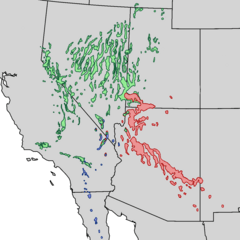
Description: Pinus monophylla range map: Green - subsp. monophylla Blue - subsp. californiarum Red - subsp. fallax
Title: Pinus monophylla range map 3
Credit: USGS Colorado Plateau Research Station: Digitized Range Maps for Modern Plants of the Southwest
Author: USGS Global Change Research Program project (Past, recent, and 21st century vegetation change in the arid south-west): Kenneth L. Cole, USGS Southwestern Biological Science Center; John Shaw, US Forest Service; John Cannella, National Park Service; and Kirsten Ironside, Northern Arizona University.
Usage Terms: Public domain
License: Public domain
Attribution Required?: No
Image usage
The following 2 pages link to this image:

All content from Kiddle encyclopedia articles (including the article images and facts) can be freely used under Attribution-ShareAlike license, unless stated otherwise.