
Image: Perth Wetlands Map1

Size of this preview: 800 × 438 pixels. Other resolutions: 320 × 175 pixels | 1,253 × 686 pixels.
Original image (1,253 × 686 pixels, file size: 104 KB, MIME type: image/png)
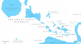
Description: A map of the former Perth Wetlands or 'Great Lakes District' constructed from a map by M. Pitt (1979), which itself was reconstructed from a map by John Septimus Roe (1834).
Title: Perth Wetlands Map1
Credit: I created this file.
Author: I created this file.
Usage Terms: Creative Commons Zero, Public Domain Dedication
License: CC0
License Link: http://creativecommons.org/publicdomain/zero/1.0/deed.en
Attribution Required?: No
Image usage
The following page links to this image:

All content from Kiddle encyclopedia articles (including the article images and facts) can be freely used under Attribution-ShareAlike license, unless stated otherwise.