
Image: Pasay City zones and barangays

Size of this preview: 558 × 600 pixels. Other resolutions: 223 × 240 pixels | 1,364 × 1,466 pixels.
Original image (1,364 × 1,466 pixels, file size: 326 KB, MIME type: image/png)
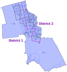
Description: This map depicts the administrative boundaries of Pasay City's subdivisions including its 2 districts, 20 zones, and 201 barangays
Title: Pasay City zones and barangays
Credit: Map derived from layers provided by OpenStreetMap France map layers service
Author: Eugene Alvin Villar (seav)
Usage Terms: Creative Commons Attribution-Share Alike 2.0
License: CC BY-SA 2.0
License Link: http://creativecommons.org/licenses/by-sa/2.0
Attribution Required?: Yes
Image usage
The following page links to this image:

All content from Kiddle encyclopedia articles (including the article images and facts) can be freely used under Attribution-ShareAlike license, unless stated otherwise.