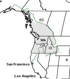
Image: PacNWComparison
Description: Modification of [:Image:CascadiaComparison.PNG], created by User:SebastianHelm for the Pacific Northwest article. Legend: Shaded area: Historical Oregon Country a.k.a Columbia District at its greatest extent; Green border: Cascadia bioregion (a.k.a. Pacific Northwest bioregion), defined as "the watersheds of rivers that flow into the Pacific Ocean through North America's temperate rainforest zone"[1]. Please feel free to edit and add other borders.
Title: PacNWComparison
Credit: No machine-readable source provided. Own work assumed (based on copyright claims).
Author: No machine-readable author provided. SebastianHelm assumed (based on copyright claims).
Usage Terms: Creative Commons Attribution-Share Alike 3.0
License: CC-BY-SA-3.0
License Link: http://creativecommons.org/licenses/by-sa/3.0/
Attribution Required?: Yes
Image usage
The following page links to this image:


