
Image: Okinawa trough topographic

Size of this preview: 600 × 600 pixels. Other resolutions: 240 × 240 pixels | 800 × 800 pixels.
Original image (800 × 800 pixels, file size: 170 KB, MIME type: image/png)
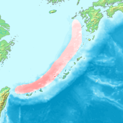
Description: Map of the Okiniwa Trough (a trough in north of Ryukyu Islands). ■ : Okinawa Trough
Title: Okinawa trough topographic
Credit: Image:Topographic30deg_N30E120.png, Image:Topographic30deg_N0E120.png, Seiyo City Geological Museum homepage
Author: Peka
Usage Terms: Creative Commons Attribution-Share Alike 3.0
License: CC-BY-SA-3.0
License Link: http://creativecommons.org/licenses/by-sa/3.0/
Attribution Required?: Yes
Image usage
The following page links to this image:

All content from Kiddle encyclopedia articles (including the article images and facts) can be freely used under Attribution-ShareAlike license, unless stated otherwise.