
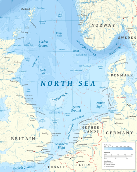
Image: North Sea map-en

Size of this preview: 479 × 600 pixels. Other resolutions: 192 × 240 pixels | 2,475 × 3,100 pixels.
Original image (2,475 × 3,100 pixels, file size: 3.8 MB, MIME type: image/png)
Description: Map of the North Sea — in northern Europe including sea depths and the EZZs.
Title: North Sea map-en
Credit: Own work using en:GRASS GIS, en:Inkscape and en:GIMP. Data sources: Elevation and bathymetry data from NGDC ETOPO1 Coastlines, rivers and borders from NGDC World Data Bank II Exclusive economic zones from Eurosion Cities from OpenStreetMap (manually) Map Projection: Universal Transverse Mercator Typeface: Gentium Book Basic from SIL International
Author: Halava
Usage Terms: Creative Commons Attribution-Share Alike 3.0
License: CC BY-SA 3.0
License Link: http://creativecommons.org/licenses/by-sa/3.0
Attribution Required?: Yes
Image usage
The following 13 pages link to this image:
- Action of 11–12 December 1917
- Action of 15 August 1917
- Action of 19 August 1916
- Action off Noordhinder Bank
- Anglo-German naval arms race
- Battle of Dogger Bank (1916)
- Bombardment of Yarmouth and Lowestoft
- First Ostend Raid
- History of the North Sea
- Operation Nordmark
- Raid on Scarborough, Hartlepool and Whitby
- Raid on Yarmouth
- SMS Lützow

All content from Kiddle encyclopedia articles (including the article images and facts) can be freely used under Attribution-ShareAlike license, unless stated otherwise.