
Image: Nordic bread mapp tellstrom
No higher resolution available.
Nordic_bread_mapp_tellstrom.jpg (295 × 412 pixels, file size: 31 KB, MIME type: image/jpeg)
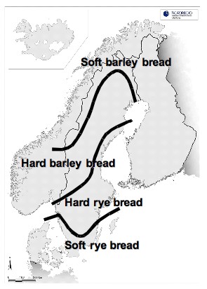
Description: A map over the Nordic countries with lines, which shows where different types of traditionally bread were used around the 1880s, according to Åke Campbell (1950)
Title: Nordic bread mapp tellstrom
Credit: From the photographer
Author: Richard Tellstrom, with a free mapp from NordRegio
Permission: The photographer has agreed to publish the work under the free license: GFDL, GNU Free Documentation License v1.1, 1.2, 1.3 and CC-BY-SA, Creative Commons Attribution ShareAlike v1.0, 2.0, 2.5, 3.0
Usage Terms: Creative Commons Attribution-Share Alike 3.0
License: CC BY-SA 3.0
License Link: https://creativecommons.org/licenses/by-sa/3.0
Attribution Required?: Yes
Image usage
The following page links to this image:

All content from Kiddle encyclopedia articles (including the article images and facts) can be freely used under Attribution-ShareAlike license, unless stated otherwise.