
Image: Newfoundland1744Annotated

Size of this preview: 800 × 483 pixels. Other resolutions: 320 × 193 pixels | 1,284 × 776 pixels.
Original image (1,284 × 776 pixels, file size: 554 KB, MIME type: image/jpeg)
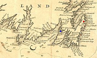
Description: Extract from a 1746 map depicting southeastern Newfoundland. In addition to crop for selection, image has had levels and colors adjusted to improve contrast, and has been annotated to show a few places of importance in Queen Anne's War. Plaisance is marked in blue, St. John's is marked with a large red spot, and Ferryland and B
Title: Newfoundland1744Annotated
Credit: Boston Public Library Norman Leventhal Map Center: http://maps.bpl.org/details_14079/
Author: Jacques Bellin; annotations by User:Magicpiano
Usage Terms: Public domain
License: Public domain
Attribution Required?: No
Image usage
The following page links to this image:

All content from Kiddle encyclopedia articles (including the article images and facts) can be freely used under Attribution-ShareAlike license, unless stated otherwise.