
Image: Near East 600BC

Size of this PNG preview of this SVG file: 800 × 575 pixels. Other resolution: 320 × 230 pixels.
Original image (SVG file, nominally 2,102 × 1,510 pixels, file size: 4.93 MB)
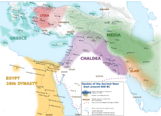
Description: Map of the Near East around 600 BC.
Title: Near East 600BC
Credit: This file has been extracted from another file
Author: Enyavar (German original), Redx360 (English translation)
Usage Terms: Creative Commons Attribution-Share Alike 4.0
License: CC BY-SA 4.0
License Link: https://creativecommons.org/licenses/by-sa/4.0
Attribution Required?: Yes
Image usage
The following page links to this image:

All content from Kiddle encyclopedia articles (including the article images and facts) can be freely used under Attribution-ShareAlike license, unless stated otherwise.