
Image: NWT-YT Inuvialuit Settlement Locator

Size of this PNG preview of this SVG file: 620 × 599 pixels. Other resolution: 248 × 240 pixels.
Original image (SVG file, nominally 1,350 × 1,305 pixels, file size: 1.41 MB)
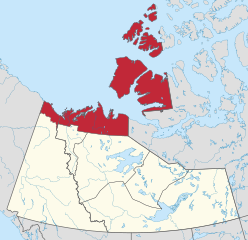
Description: Locator map showing full (c. 2019) extent of the Inuvialuit settlement region across Yukon and Northwest Territories, Canada. Boundaries derived from textual and federal government sources. Physical geography derived from NaturalEarth dataset. Projection: custom Transverse Mercator centered on 120W.
Title: NWT-YT Inuvialuit Settlement Locator
Credit: Own work
Author: awmcphee
Usage Terms: Creative Commons Attribution-Share Alike 4.0
License: CC BY-SA 4.0
License Link: https://creativecommons.org/licenses/by-sa/4.0
Attribution Required?: Yes
Image usage
The following 3 pages link to this image:

All content from Kiddle encyclopedia articles (including the article images and facts) can be freely used under Attribution-ShareAlike license, unless stated otherwise.