
Image: Minimum extension Dotawo after 1365
No higher resolution available.
Minimum_extension_Dotawo_after_1365.png (330 × 390 pixels, file size: 7 KB, MIME type: image/png)
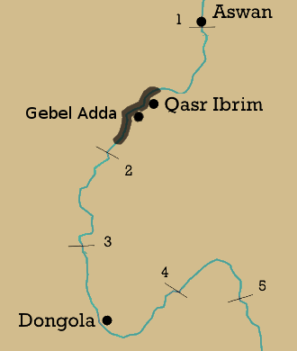
Description: This map depicts the minimum extension of Makuria after the relocation of the capital to Daw aka Gebel Adda. It is based on documents from Qasr Ibrim, attesting an extension from Tomas in the north to Adindan in the south, making a north-south extension of almost 100 km. Source: Roland Werner: "Das Christentum in Nubien. Geschichte und Gestalt einer afrikanischen Kirche"
Title: Minimum extension Dotawo after 1365
Credit: Own work
Author: LeGabrie
Usage Terms: Creative Commons Attribution-Share Alike 4.0
License: CC BY-SA 4.0
License Link: https://creativecommons.org/licenses/by-sa/4.0
Attribution Required?: Yes
Image usage
The following page links to this image:

All content from Kiddle encyclopedia articles (including the article images and facts) can be freely used under Attribution-ShareAlike license, unless stated otherwise.