
Image: Mexico in 1822

Size of this preview: 759 × 600 pixels. Other resolutions: 304 × 240 pixels | 5,625 × 4,445 pixels.
Original image (5,625 × 4,445 pixels, file size: 2.51 MB, MIME type: image/jpeg)
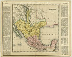
Description: This is a map of Mexico in 1822.
Title: Mexico in 1822
Credit: This scanned image has been taken from the Texas State Archives.[1] The map was originally printed as part of an atlas, A Complete Historical, Chronological, and Geographical American Atlas,... by H.C. Carey, (H.C. Carey and I. Lea, Philadelphia, 1822).
Author: Henry Charles Carey
Usage Terms: Public domain
License: Public domain
Attribution Required?: No
Image usage
The following page links to this image:

All content from Kiddle encyclopedia articles (including the article images and facts) can be freely used under Attribution-ShareAlike license, unless stated otherwise.