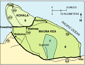
Image: Mauna Kea and Kohala Volcanic Hazard Mapping
Mauna_Kea_and_Kohala_Volcanic_Hazard_Mapping.gif (354 × 269 pixels, file size: 25 KB, MIME type: image/gif)
Description: Threat mapping of Kohala and of Mauna Kea, on a scale of 1 to 9 with 1 being most dangerous (certain areas of Kilauea) and 9 (Kohala) the least.
Usage Terms: Public domain
Image usage
The following page links to this image:

All content from Kiddle encyclopedia articles (including the article images and facts) can be freely used under Attribution-ShareAlike license, unless stated otherwise.

