
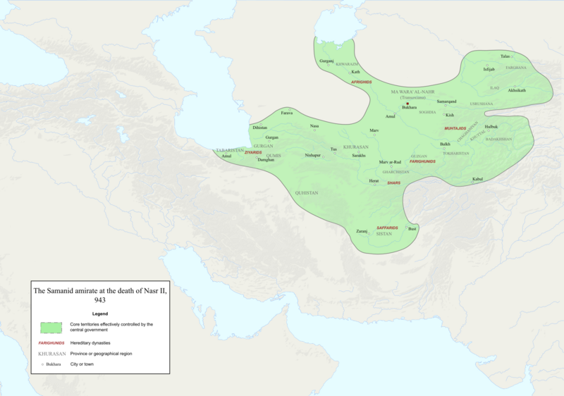
Image: Map of the Samanid amirate at the death of Nasr II, 943

Description: Map of the Samanid amirate at the death of Nasr II.
Title: Map of the Samanid amirate at the death of Nasr II, 943
Credit: Map is mainly based on two maps of mid 10th-century Central Asia under the Samanids in the pages 23 and 25 of An Historical Atlas of Central Asia, written by Yuri Bregel and published by Brill, supplied by NAṢR (I) B. AḤMAD (I) B. ESMĀʿIL [1] and Frye, R. N. (1975). "The Sāmānids". In Frye, Richard N. (ed.). The Cambridge History of Iran, Volume 4: From the Arab Invasion to the Saljuqs. Cambridge: Cambridge University Press. pp. 136–161. Since the maps in the source "only" showed Central Asia, I was missing very few parts of the southern border of the Samanids, which I used the following sources to construct; Frye, R. N. (1975). "The Sāmānids". In Frye, Richard N. (ed.). The Cambridge History of Iran, Volume 4: From the Arab Invasion to the Saljuqs. Cambridge: Cambridge University Press. Page 139. ISBN 0-521-20093-8. O'Neal, Michael (2015). "Ghūrids". In Fleet, Kate; Krämer, Gudrun; Matringe, Denis; Nawas, John; Rowson, Everett (eds.). Encyclopaedia of Islam, THREE. Brill Online. ISSN 1873-9830 SISTĀN ii. In the Islamic period [2] SAFFARIDS [3] NAṢR (I) B. AḤMAD (I) B. ESMĀʿIL [4]
Author: Original file by Ro4444, edited by me
Permission: File:Abbasid_Caliphate_891-892.png
Usage Terms: Creative Commons Attribution-Share Alike 4.0
License: CC BY-SA 4.0
License Link: https://creativecommons.org/licenses/by-sa/4.0
Attribution Required?: Yes
Image usage
The following page links to this image:
