
Image: Map of New York highlighting Southern Tier
No higher resolution available.
Map_of_New_York_highlighting_Southern_Tier.png (300 × 232 pixels, file size: 12 KB, MIME type: image/png)
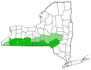
Description: Southern Tier Counties, New York State. Darker green indicates most commonly referred to as "Southern Tier Counties." Light green indicates other counties occasionally associated with the Southern Tier.
Title: Map of New York highlighting Southern Tier
Credit: Transferred from en.wikipedia to Commons.
Author: The original uploader was Decumanus at English Wikipedia Later versions were uploaded by JMyrleFuller at en.wikipedia.
Usage Terms: Creative Commons Attribution-Share Alike 3.0
License: CC-BY-SA-3.0
License Link: http://creativecommons.org/licenses/by-sa/3.0/
Attribution Required?: Yes
Image usage
There are no pages that link to this image.

All content from Kiddle encyclopedia articles (including the article images and facts) can be freely used under Attribution-ShareAlike license, unless stated otherwise.