
Image: Map of Lakshadweep-en

Size of this PNG preview of this SVG file: 435 × 600 pixels. Other resolution: 174 × 240 pixels.
Original image (SVG file, nominally 889 × 1,226 pixels, file size: 242 KB)
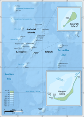
Description: Map of Lakshadweep.
Title: Map of Lakshadweep-en
Credit: Own work. Self-made in Inkscape. Based on the 1976 CIA Indian Ocean Atlas (http://www.lib.utexas.edu/maps/islands_oceans_poles/laccadive_minicoy_76.jpg); bathymetry from SRTM30_PLUS.
Author: Oona Räisänen (Mysid)
Usage Terms: Creative Commons Attribution-Share Alike 3.0
License: CC BY-SA 3.0
License Link: https://creativecommons.org/licenses/by-sa/3.0
Attribution Required?: Yes
Image usage
The following page links to this image:

All content from Kiddle encyclopedia articles (including the article images and facts) can be freely used under Attribution-ShareAlike license, unless stated otherwise.