
Image: Map Saipan Tinian islands closer
No higher resolution available.
Map_Saipan_Tinian_islands_closer.jpg (290 × 410 pixels, file size: 31 KB, MIME type: image/jpeg)
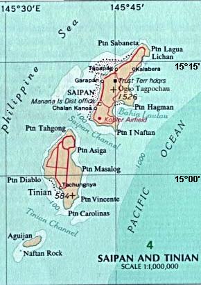
Description: Map of the islands of Saipan and Tinian in the Northern Mariana Islands along the Marianas Trench (east of China and the Philippines).
Title: Map Saipan Tinian islands closer
Credit: Derived by cropping US Government (USNA) map: http://www.lib.utexas.edu/maps/australia/saipan_tinian_islands.jpg linked as being a US National Atlas (1970) map on related webpage: http://www.lib.utexas.edu/maps/northern_mariana_islands.html .
Author: map:US Geological Survey crop:Wikid77
Usage Terms: Public domain
License: Public domain
Attribution Required?: No
Image usage

All content from Kiddle encyclopedia articles (including the article images and facts) can be freely used under Attribution-ShareAlike license, unless stated otherwise.