
Image: Map Mariana Islands volcanoes

Size of this preview: 394 × 599 pixels. Other resolutions: 158 × 240 pixels | 400 × 608 pixels.
Original image (400 × 608 pixels, file size: 19 KB, MIME type: image/gif)
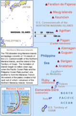
Description: Map describing volcanoes of the Mariana Islands along the Marianas Trench (east of China and the Philippines).
Title: Map Mariana Islands volcanoes
Credit: Derived by cropping US Government (USGS) map: http://vulcan.wr.usgs.gov/Imgs/Gif/MarianaIslands/Maps/map_mariana_islands_volcanoes.gif
Author: Wikid77
Usage Terms: Public domain
License: Public domain
Attribution Required?: No
Image usage
The following page links to this image:

All content from Kiddle encyclopedia articles (including the article images and facts) can be freely used under Attribution-ShareAlike license, unless stated otherwise.