
Image: MapKoksijde

Size of this PNG preview of this SVG file: 800 × 554 pixels. Other resolution: 320 × 222 pixels.
Original image (SVG file, nominally 1,285 × 890 pixels, file size: 57 KB)
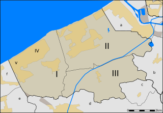
Description: Map of Koksijde, West-Flanders, Belgium, neighbourhoods within the municipality and its neighbours. Koksijde: I. Koksijde [IV. Koksijde-bad, part of Koksijde] [V. Sint-Idesbald, part of Koksijde] II. Oostduinkerke III. Wulpen Neighbouring villages: a. Nieuwpoort b. Ramskapelle (Nieuwpoort) c. Booitshoeke (Veurne) d. Veurne e. Adinkerke (De Panne) f. De Panne The orange/yellow areas are urban areas; the other areas are rural areas with lower density population.
Title: MapKoksijde
Credit: Own work
Author: nl:User:LimoWreck
Usage Terms: Creative Commons Attribution 2.5
License: CC BY 2.5
License Link: https://creativecommons.org/licenses/by/2.5
Attribution Required?: Yes
Image usage
The following page links to this image:

All content from Kiddle encyclopedia articles (including the article images and facts) can be freely used under Attribution-ShareAlike license, unless stated otherwise.