
Image: Maharashtra Divisions Eng

Size of this PNG preview of this SVG file: 759 × 599 pixels. Other resolution: 304 × 240 pixels.
Original image (SVG file, nominally 3,106 × 2,453 pixels, file size: 248 KB)
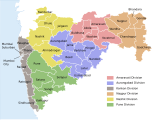
Description: Locator map of the state of en:Maharashtra, India with district boundaries and Admin. divisions
Title: Maharashtra Divisions Eng
Credit: Maharashtra_locator_map.svg
Author: Maharashtra_locator_map.svg: User:PlaneMad derivative work: Kaajawa (talk)
Usage Terms: Creative Commons Attribution-Share Alike 3.0
License: CC BY-SA 3.0
License Link: https://creativecommons.org/licenses/by-sa/3.0
Attribution Required?: Yes
Image usage
The following page links to this image:

All content from Kiddle encyclopedia articles (including the article images and facts) can be freely used under Attribution-ShareAlike license, unless stated otherwise.