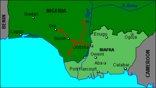
Image: MIdwest Invasion of 1967 map

Size of this PNG preview of this SVG file: 512 × 291 pixels. Other resolution: 320 × 182 pixels.
Original image (SVG file, nominally 512 × 291 pixels, file size: 34 KB)
Description: Approximate lines of attack used by the Biafran forces during the Midwest Invasion of 1967. The northern pincer is to Auchi and Okene, while the southern pincer is towards Sapele, Warri and Ughelli.
Title: MIdwest Invasion of 1967 map
Credit: Own work
Author: 141 126 210 103 account
Usage Terms: Creative Commons Attribution-Share Alike 4.0
License: CC BY-SA 4.0
License Link: https://creativecommons.org/licenses/by-sa/4.0
Attribution Required?: Yes
Image usage
The following page links to this image:

All content from Kiddle encyclopedia articles (including the article images and facts) can be freely used under Attribution-ShareAlike license, unless stated otherwise.
