
Image: Lurgan High Street, 1960 geograph-3773914-by-Ben-Brooksbank

Size of this preview: 800 × 504 pixels. Other resolutions: 320 × 202 pixels | 2,341 × 1,475 pixels.
Original image (2,341 × 1,475 pixels, file size: 1.23 MB, MIME type: image/jpeg)
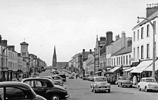
Description: Lurgan: High Street, 1960. View northward, to St Peter's Church (now Shankill Parish Church or Christ Church (C of I)) at the end, up Market Street and Church Place. The tower on the left is the Mechanic's Institute on the corner of Union Street.
Title: Lurgan High Street, 1960 geograph-3773914-by-Ben-Brooksbank
Credit: From geograph.org.uk
Author: Ben Brooksbank
Permission: Creative Commons Attribution Share-alike license 2.0
Usage Terms: Creative Commons Attribution-Share Alike 2.0
License: CC BY-SA 2.0
License Link: http://creativecommons.org/licenses/by-sa/2.0
Attribution Required?: Yes
Image usage
The following page links to this image:

All content from Kiddle encyclopedia articles (including the article images and facts) can be freely used under Attribution-ShareAlike license, unless stated otherwise.