
Image: Location map of Whitley County, Indiana

Size of this PNG preview of this SVG file: 600 × 600 pixels. Other resolution: 240 × 240 pixels.
Original image (SVG file, nominally 960 × 960 pixels, file size: 832 KB)
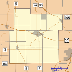
Description: This is a map of Whitley County, Indiana, USA which includes incorporated settlements, township borders, and major highways.
Title: Location map of Whitley County, Indiana
Credit: My own work, using custom-written MapScript applications with United States Census Bureau data
Author: Omnedon
Usage Terms: Public domain
License: Public domain
Attribution Required?: No
Image usage
The following 18 pages link to this image:
- Briggs, Indiana
- Coesse, Indiana
- Coesse Corners, Indiana
- Collamer, Indiana
- Collins, Indiana
- Cresco, Indiana
- Dunfee, Indiana
- Etna, Indiana
- Five Points, Whitley County, Indiana
- Laud, Indiana
- Lorane, Indiana
- Luther, Indiana
- Ormas, Indiana
- Peabody, Indiana
- Raber, Indiana
- Tunker, Indiana
- Walnut Corners, Indiana
- Washington Center, Indiana

All content from Kiddle encyclopedia articles (including the article images and facts) can be freely used under Attribution-ShareAlike license, unless stated otherwise.