
Image: Location map of Wells County, Indiana

Size of this PNG preview of this SVG file: 600 × 600 pixels. Other resolution: 240 × 240 pixels.
Original image (SVG file, nominally 960 × 960 pixels, file size: 1.15 MB)
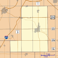
Description: This is a map of Wells County, Indiana, USA which includes incorporated settlements, township borders, and major highways.
Title: Location map of Wells County, Indiana
Credit: My own work, using custom-written MapScript applications with United States Census Bureau data
Author: Omnedon
Usage Terms: Public domain
License: Public domain
Attribution Required?: No
Image usage
The following 24 pages link to this image:
- Craigville, Indiana
- Curryville, Indiana
- Dillman, Indiana
- Domestic, Indiana
- Five Points, Wells County, Indiana
- Greenville, Wells County, Indiana
- Greenwood, Wells County, Indiana
- Jeff, Indiana
- Keystone, Indiana
- Kingsland, Indiana
- Liberty Center, Indiana
- McNatts, Indiana
- Mount Zion, Indiana
- Murray, Indiana
- North Oaks, Indiana
- Nottingham, Indiana
- Petroleum, Indiana
- Phenix, Indiana
- Reiffsburg, Indiana
- Rockford, Wells County, Indiana
- Tocsin, Indiana
- Toll Gate Heights, Indiana
- Travisville, Indiana
- Wellsburg, Indiana

All content from Kiddle encyclopedia articles (including the article images and facts) can be freely used under Attribution-ShareAlike license, unless stated otherwise.