
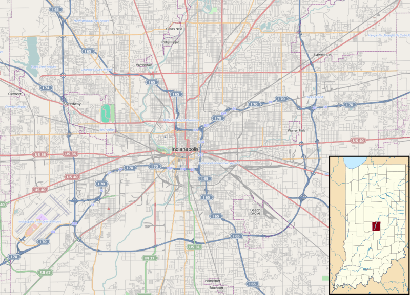
Image: Location map Indianapolis

Size of this preview: 800 × 577 pixels. Other resolutions: 320 × 231 pixels | 1,154 × 833 pixels.
Original image (1,154 × 833 pixels, file size: 1,012 KB, MIME type: image/png)
Description: Map of Indianapolis Geographic limits of the map: N: 39.879° S: 39.66° W: -86.337° E: -85.941°
Title: Location map Indianapolis
Credit: Maps for Free (OSM) . Insert is based on File:USA Indiana location map.svg
Author: Dr. Blofeld. Insert by Alexrk2
Usage Terms: Creative Commons Attribution-Share Alike 2.0
License: CC BY-SA 2.0
License Link: https://creativecommons.org/licenses/by-sa/2.0
Attribution Required?: Yes
Image usage
The following 64 pages link to this image:
- Athenæum (Das Deutsche Haus)
- Bates–Hendricks
- Benjamin Harrison Presidential Site
- Beth-El Zedeck Temple
- Bethel A.M.E. Church (Indianapolis, Indiana)
- Birch Bayh Federal Building and United States Courthouse
- Broad Ripple Park Carousel
- Cole Motor Car Company
- Cottage Home Historic District
- Crown Hill National Cemetery
- Flanner House Homes
- Fort Benjamin Harrison
- Gainbridge Fieldhouse
- George Stumpf House
- Golden Hill Historic District (Indianapolis, Indiana)
- H. P. Wasson and Company
- Haughville, Indianapolis
- Herron–Morton Place Historic District
- Hinkle Fieldhouse
- Indiana Avenue
- Indiana Medical History Museum
- Indiana State Federation of Colored Women's Clubs
- Indiana State Library and Historical Bureau
- Indiana Statehouse
- Indiana Theatre (Indianapolis)
- Indiana World War Memorial Plaza
- Indianapolis Masonic Temple
- Indianapolis Motor Speedway
- Indianapolis Public Library
- Indianapolis Union Station
- Indianapolis White Castle
- Irvington Historic District (Indianapolis)
- James Whitcomb Riley Museum Home
- Kahn Tailoring Company Building
- Lockefield Gardens
- Lockerbie Square Historic District
- Lovel D. Millikan House
- Madam Walker Legacy Center
- Marcy Village Apartments
- Military Park (Indianapolis)
- Morris–Butler House
- Mt. Pisgah Lutheran Church
- Nicholson–Rand House
- North Irvington Gardens Historic District
- Old Northside Historic District
- Oldfields
- Oliver Johnson's Woods Historic District
- Omni Severin Hotel
- Ransom Place Historic District
- Roberts Park Methodist Episcopal Church
- Saints Peter and Paul Cathedral (Indianapolis)
- Schnull–Rauch House
- Scottish Rite Cathedral (Indianapolis)
- Slippery Noodle Inn
- Soldiers' and Sailors' Monument (Indianapolis)
- South Side Turnverein Hall
- St. Mary's Catholic Church (Indianapolis, Indiana)
- Tee Pee Restaurant
- The Columbia Club
- The Propylaeum
- Washington Park Historic District (Indianapolis, Indiana)
- Wheeler–Schebler Carburetor Company
- Wholesale District, Indianapolis
- Woodruff Place, Indianapolis

All content from Kiddle encyclopedia articles (including the article images and facts) can be freely used under Attribution-ShareAlike license, unless stated otherwise.