
Image: LocationFederationofArabEmirates
No higher resolution available.
LocationFederationofArabEmirates.png (250 × 115 pixels, file size: 3 KB, MIME type: image/png)
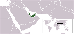
Description: Map of the Federation of Arab Emirates, a former planned federation between Bahrain, Qatar and the Trucial States in 1968.
Title: LocationFederationofArabEmirates
Credit: Own work
Author: JCIV
Usage Terms: Creative Commons Attribution-Share Alike 3.0
License: CC BY-SA 3.0
License Link: http://creativecommons.org/licenses/by-sa/3.0/
Attribution Required?: Yes
Image usage
The following 3 pages link to this image:

All content from Kiddle encyclopedia articles (including the article images and facts) can be freely used under Attribution-ShareAlike license, unless stated otherwise.