
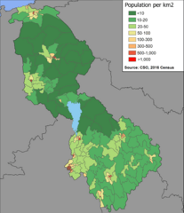
Image: Leitrim Density Map 2016

Size of this preview: 517 × 599 pixels. Other resolutions: 207 × 240 pixels | 2,136 × 2,476 pixels.
Original image (2,136 × 2,476 pixels, file size: 231 KB, MIME type: image/png)
Description: Population Density Map of County Leitrim by Small Area (SA), based on Census 2016 data compiled by AIRO Maynooth
Title: Leitrim Density Map 2016
Credit: Own work
Author: Jacobfrid
Usage Terms: Creative Commons Attribution-Share Alike 4.0
License: CC BY-SA 4.0
License Link: https://creativecommons.org/licenses/by-sa/4.0
Attribution Required?: Yes
Image usage
The following page links to this image:

All content from Kiddle encyclopedia articles (including the article images and facts) can be freely used under Attribution-ShareAlike license, unless stated otherwise.