
Image: Latium -5th Century map-en

Size of this PNG preview of this SVG file: 800 × 600 pixels. Other resolution: 320 × 240 pixels.
Original image (SVG file, nominally 900 × 675 pixels, file size: 321 KB)
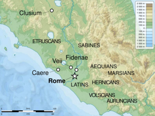
Description: Map of Latium in the 5th century BC.
Title: Latium -5th Century map-en
Credit: Own work. Source : File:Italy_topographic_map-blank.svg by Sting under licence GFDL or CC-BY-SA 3.0 File:Central_Italian_Ancient_Peoples.jpg by Ursus under licence Public Domain
Author: Sémhur (talk)
Usage Terms: Creative Commons Attribution-Share Alike 4.0
License: CC BY-SA 4.0
License Link: https://creativecommons.org/licenses/by-sa/4.0
Attribution Required?: Yes
Image usage
The following page links to this image:

All content from Kiddle encyclopedia articles (including the article images and facts) can be freely used under Attribution-ShareAlike license, unless stated otherwise.