
Image: Kutz Bridge - Independence Ave SW- Washington DC

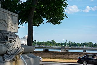
Description: Looking south across Independence Avenue SW (foreground) at the Kutz Bridge, which carries eastbound Independence Avenue SW over the northern bay of the Tidal Basin in Washington, D.C., in the United States. The Jefferson Memorial can be see in the left distance, on the far side of the Tidal Basin. The land visible here did not exist until 1881, when the Army Corps of Engineers began dredging the Potomac River in an attempt to deepen the channel to prevent flooding. The dredged material was dumped to create the western end of the National Mall (West Potomac Park) and an artificial island and waterway to the Mall's southeast (East Potomac Park and the Washington Channel). This area was complete about 1910. The Tidal Basin was completed in 1917 as a means of helping to flush the Washington Channel. Independence Avenue originally stopped at 15th Street SW, where the shore of the Potomac River used to be. It was not extended westward until 1941 (the idea was that it would link with the western part of the city to help move defense workers about the capital more easily). Originally, the Tidal Basin was more like four small lakes. Nontheless, westbound Independence Avenue was forced to curve north around it. The eastbound lanes actually crossed the Tidal Basin via a new bridge, Kutz Bridge (finished in 1943). In 1949, the Tidal Basin was given its current shape, but the northern bay remains.
Title: Kutz Bridge - Independence Ave SW- Washington DC
Credit: https://www.flickr.com/photos/23165290@N00/14264094956
Author: Tim Evanson
Usage Terms: Creative Commons Attribution-Share Alike 2.0
License: CC BY-SA 2.0
License Link: https://creativecommons.org/licenses/by-sa/2.0
Attribution Required?: Yes
Image usage
The following page links to this image:
