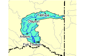
Image: Kiamichi Watershed Localized
Description: Map of the watershed of the Kiamichi River in Oklahoma. The view is of the river from its headwaters to its confluence with the Red River.
Title: Kiamichi Watershed Localized
Credit: http://images.google.com/imgres?imgurl=http://www.epa.gov/surf/hucs/images/11140105.gif&imgrefurl=http://cfpub.epa.gov/surf/huc.cfm%3Fhuc_code%3D11140105&usg=__cHk_4Owk_EgBMMkL3n5xJtPgv7c=&h=189&w=284&sz=4&hl=en&start=2&um=1&tbnid=vVm6zKISzA1oiM:&tbnh=76&tbnw=114&prev=/images%3Fq%3Dkiamichi%2Bwatershed%26hl%3Den%26client%3Dfirefox-a%26rls%3Dorg.mozilla:en-US:official%26sa%3DN%26um%3D1: http://images.google.com/imgres?imgurl=http://www.epa.gov/surf/hucs/images/11140105.gif&imgrefurl=http://cfpub.epa.gov/surf/huc.cfm%3Fhuc_code%3D11140105&usg=__cHk_4Owk_EgBMMkL3n5xJtPgv7c=&h=189&w=284&sz=4&hl=en&start=2&um=1&tbnid=vVm6zKISzA1oiM:&tbnh=76&tbnw=114&prev=/images%3Fq%3Dkiamichi%2Bwatershed%26hl%3Den%26client%3Dfirefox-a%26rls%3Dorg.mozilla:en-US:official%26sa%3DN%26um%3D1
Author: Environmental Protection Agency
Permission: Original work of the US Federal Govenment - public domain
Usage Terms: Public domain
License: Public domain
Attribution Required?: No
Image usage
The following page links to this image:


