
Image: Kamakura-Map Final

Size of this preview: 507 × 599 pixels. Other resolutions: 203 × 240 pixels | 1,104 × 1,304 pixels.
Original image (1,104 × 1,304 pixels, file size: 88 KB, MIME type: image/png)
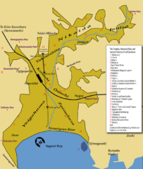
Description: A map of Kamakura, with indications for temples, shrines, the Seven Entrances and historical sites
Title: Kamakura-Map Final
Credit: Image:Kamakura-Map_Final.gif made with Adobe Illustrator CS3 by Urashimataro, converted to PNG format by Ilmari Karonen
Author: Urashimataro
Permission: Public Domain
Usage Terms: Public domain
License: Public domain
Attribution Required?: No
Image usage
The following 2 pages link to this image:

All content from Kiddle encyclopedia articles (including the article images and facts) can be freely used under Attribution-ShareAlike license, unless stated otherwise.