
Image: Kïlauea summit area map

Size of this preview: 425 × 599 pixels. Other resolutions: 170 × 240 pixels | 507 × 715 pixels.
Original image (507 × 715 pixels, file size: 151 KB, MIME type: image/jpeg)
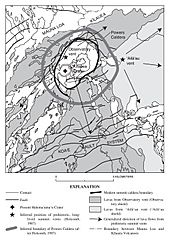
Description: Map of the Kïlauea summit area showing probable locations of prehistoric vents, calderas and flows.
Title: Kïlauea summit area map
Credit: Neal, Christina A.; Lockwood, John P. (2003). "Geologic Map of the Summit Region of Kïlauea Volcano, Hawaii". United States Geological Survey: 6.
Author: USGS
Permission: See below
Usage Terms: Public domain
License: Public domain
Attribution Required?: No
Image usage
The following page links to this image:

All content from Kiddle encyclopedia articles (including the article images and facts) can be freely used under Attribution-ShareAlike license, unless stated otherwise.