
Image: Itinerario legazpi

Size of this preview: 274 × 598 pixels. Other resolutions: 110 × 240 pixels | 328 × 716 pixels.
Original image (328 × 716 pixels, file size: 70 KB, MIME type: image/jpeg)
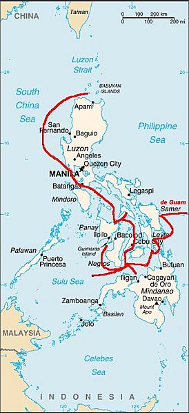
Description: Map of the 1560s Miguel López de Legazpi expedition, the route of European discovery of the Philippines, after crossing the Pacific from the Viceroyalty of New Spain (México). The Spanish navigator also established the Spanish East Indies (colonial Philippines), and the first Spanish settlement there, founding Cebu in 1565.
Title: Itinerario legazpi
Credit: No machine-readable source provided. Own work assumed (based on copyright claims).
Author: No machine-readable author provided. Txo assumed (based on copyright claims).
Usage Terms: Public domain
License: Public domain
Attribution Required?: No
Image usage
The following 3 pages link to this image:

All content from Kiddle encyclopedia articles (including the article images and facts) can be freely used under Attribution-ShareAlike license, unless stated otherwise.