
Image: Isabella's invasion route (1326)

Size of this PNG preview of this SVG file: 650 × 400 pixels. Other resolution: 320 × 197 pixels.
Original image (SVG file, nominally 650 × 400 pixels, file size: 464 KB)
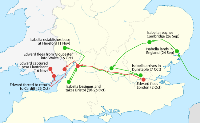
Description: Map depicting Isabella of France's invasion of England
Title: Isabella's invasion route (1326)
Credit: Data set of route: Weir's "Isabella: She Wolf of France" Mortimer's "The Greatest Traitor" Myer's "England in the Late Middle Ages" details on medieval roads and trade routes Map redrawn according to: File:Isabella's and Mortimer's invasion route, 1326.png File:Isabella's invasion route (1326).png
Author: Cypp0847
Usage Terms: Creative Commons Attribution-Share Alike 4.0
License: CC BY-SA 4.0
License Link: https://creativecommons.org/licenses/by-sa/4.0
Attribution Required?: Yes
Image usage
The following 3 pages link to this image:

All content from Kiddle encyclopedia articles (including the article images and facts) can be freely used under Attribution-ShareAlike license, unless stated otherwise.
.svg)