
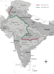
Image: Inland Customs Line India

Size of this preview: 442 × 599 pixels. Other resolutions: 177 × 240 pixels | 880 × 1,192 pixels.
Original image (880 × 1,192 pixels, file size: 197 KB, MIME type: image/png)
Description: Map of the Inland Customs line and Great Hedge of India as it existed in the 1870's. http://www.rmoxham.freeserve.co.uk/maps.htm by Richard Moxham used as reference for location of line and hedge.
Title: Inland Customs Line India
Credit: British_india.png
Author: Derivative of British_india.png (by Kmusser), changes made by Dumelow. derivative work: Dumelow (talk)
Usage Terms: Creative Commons Attribution 3.0
License: CC BY 3.0
License Link: https://creativecommons.org/licenses/by/3.0
Attribution Required?: Yes
Image usage
The following page links to this image:

All content from Kiddle encyclopedia articles (including the article images and facts) can be freely used under Attribution-ShareAlike license, unless stated otherwise.