
Image: Iceland Mid-Atlantic Ridge Fig16
No higher resolution available.
Iceland_Mid-Atlantic_Ridge_Fig16.gif (376 × 390 pixels, file size: 9 KB, MIME type: image/gif)
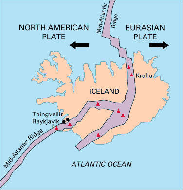
Description: Map showing the Mid-Atlantic Ridge splitting Iceland and separating the North American and Eurasian Plates. The map also shows Reykjavik, the capital of Iceland, the Thingvellir area, and the locations of some of Iceland's active volcanoes (red triangles), including Krafla.
Title: Iceland Mid-Atlantic Ridge Fig16
Credit: pubs.usgs.gov
Author: USGS
Usage Terms: Public domain
License: Public domain
Attribution Required?: No
Image usage
The following page links to this image:

All content from Kiddle encyclopedia articles (including the article images and facts) can be freely used under Attribution-ShareAlike license, unless stated otherwise.